A ground validation campaign has been occured in summer 2012, at The MT West Africa MTGV super site in Ouagadougou, Burkina Faso. Located at 12°3 North, 1°5 Ouest, the place is ideally situated compared to MT orbit (6 overpass /day zone) and the rainfall regime is reprentative of the Sahelian climate, with intensive MCS during the Monsoon season. During 3 months, The Xport radar was operated and 2 dedicaced radio-sounding campaigns have been done.
-The Xport polarimetric radar hosted at the DGM (Direction Générale de la Météorologie of Burkina Faso) provides high resolution rainfield and the 3D structure of precipitations, to be compared with the MT-BRAIN product .
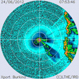
See the latest radar quicklooks from our on going Ouagadougou campaign – Caution ! this is raw uncorrected uncalibrated data, only for quick-look purposes :
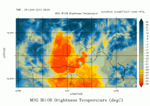
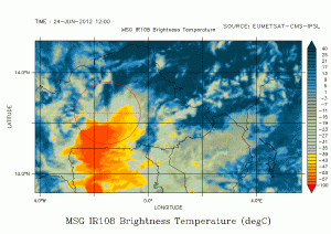
Bellow: An example of the raw (uncorrected for attenuation and unfiltered) Xport reflectivities over Ouagadougou while the squall line seen on the MSG images is passing over the site.

–Intensive radio-soundings campaign are launched from the ASECNA site to document precisely the water vapor content of the atmosphere:
The first Radio-Sounding Campaign dedicated to MT-SAPHIR based Water Vapor products validation covered the 29th May – 11th June 2012 (15 days) thanks to a lot of support from ASECNA (Agence pour la SECurité de la NAvigation Aerienne en Afrique et Madagascar).
The second phase of this Campaign was aimed at sampling the moister atmosphere in the heart of the African Monsson and cover the 17th July – 2nd August period (2012). Every day a pair of radio-sounding was launched in synchronization with Megha-Tropiques overpasses. The 2 RS were launched 35 min apart to allow simultaneous sampling of the lower and upper part of the troposphere while MT is overpassing.
During those 2 phases, 60 radio-soundings were successfully launched.
The measurements are currently quality checked using various tools (e.g. the ASPEN developped by NCAR-EOL) and examined through a collaboration in the GRUAN framework (collab with H. Vömel and M. Sommer).
Below are shown the skew-t diagram and trajectory for one launch performed during the pre-monsoon phase; the UTC time is the begining of the RS launch, 45 minutes before Meghat-Topriques overpass:
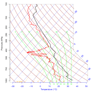
Exemple of a skew-T diagram for the RS data of 3 june 2012 14h36 (UTC)
Radio-sounding animation for the 3 june 2012 14h36 (UTC)