B. Mission Characteristics
Timing
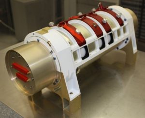
Dramatic events in the tropical area, repetitive droughts in specific areas of the Tropics as Africa, eventually linked to long terms tendencies in climate, show practically the importance of improving our knowledge of the tropical water and energy cycle in the context of climate variability. TROPIQUES has been first defined in the frame of “small satellite missions” of CNES. Discussions with ISRO, the Indian space agency, concluded to the possibility of a joint mission, which was called MEGHA-TROPIQUES. After some problems in the advancement of the project and negociations on the sharing between India and France, the project has been reconducted in 2005, with a launch on an Indian platform by the Indian launcher PSLV in october 2011. The realization of the main instrument (MADRAS) is shared between France and India, while the two others, ScaRaB and SAPHIR, are provided by France.
Duration
This mission is an experimental mission without plan for operational follow-up. In order to be able to study time scales from the scale of the large convective events to interannual variations, the duration of the mission should be 5 years.
Relation/dependence to other missions
The mission, which will benefit of the experience gained from TRMM , has to take into account TRMM follow-on projects, specially the project of a network of small satellites (in the frame of the Global Precipitation Mission , GPM) carrying microwave radiometers for sampling globally the rainfall.
Observation requirements
Sampling, orbit, swath:
As said above, the key of this mission is the repetitivity of the measurement in the Tropics. One has to combine the choice of the inclination of the orbit, the scanning capability of the instruments and the height of the orbit. The limitation of the swath is determined mainly by the microwave imager, which has a conical swath. Simulations have shown that it was possible to obtain a repetitivity of more than 3.5 visibilities per day of each point of the zone situated between 22°S and 22°N for an orbit inclination of 20° at 866-km height. The repetitivity reaches more than 5 per day around 13°N and 13°S.
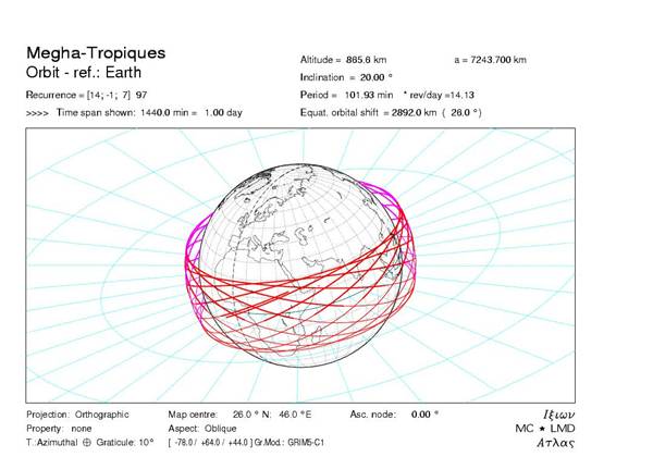
Figure 1 : Megha-tropiques orbit for a 1-day period.
Space resolution, geometry of observation:
The space resolution should be adapted to the scale of the main objects studied, the large convective complexes of the Tropical areas. The requirements do not call for resolution of individual convective cells, which can be smaller than 10 km in horizontal extent. A resolution of 10 km is estimated sufficient for localizing the active convective parts of the systems with the microwave imager. It appears also reasonable for obtaining enough clear air measurements, between the clouds, with the humidity-profiling instrument. A still lower resolution (40 km) appears acceptable for other parameters determination: liquid water content, radiative budget components at Top of the Atmosphere. The geometry of observation has to be conical scanning for the microwave imager, as the incidence has to be constant in order to use the polarization information. For the other instruments (sounder and radiative budget), a cross track scanning is acceptable. The general Geometry of scanning of the three instruments of the mission is represented on figure 2.
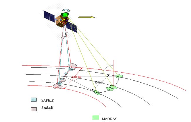
Figure 2 : General configuration of the swath of the three instruments of Megha-Tropiques. Size of the footprints has been enhanced in order to show their geometric behaviour.
Spectral characteristics of the instruments:
Three instruments compose the core payload of the mission: a microwave imager, a microwave water vapor sounder, a radiative budget radiometer. Preliminary studies have defined the main characteristics of these instruments. Their overall spectral characteristics are given below:
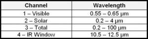
MADRAS
MADRAS (Microwave Analysis and Detection of Rain and Atmospheric Systems) is a microwave imager, with conical scanning (incidence angle 56°), close from the SSM/I and TMI concepts. The main aim of the mission being the study of cloud systems, a frequency has been added (157 Ghz) in order to study the high level ice clouds associated with the convective systems, and to serve as a window channel relative to the sounding instrument at 183 GHz.
| Frequencies | Polarization | Pixel size | Main use |
| 18.7 Ghz ± 100 Mhz | H + V | 40 km | ocean rain and surface wind |
| 23.8 Ghz ± 200 Mhz | V | 40 km | integrated water vapor |
| 36.5 Ghz ± 500 Mhz | H + V | 40 km | cloud liquid water |
| 89 Ghz ± 1350 Mhz | H + V | 10 km | convective rain areas |
| 157 Ghz ± 1350 Mhz | H + V | 6 km | cloud top ice |
Table 1 : main characteristics of the MADRAS channels
The main uses given here are only indicative, most of the products being extracted from algorithms combining the different channels information. The resolutions are those expected in the different channels, accounting for the specification of 10 km given for the 89 Ghz channel.
SAPHIR
SAPHIR (Sondeur Atmosphérique du Profil d’Humidité Intertropicale par Radiométrie) is a sounding instrument with 6 channels near the absorption band of water vapor at 183 Ghz. These channels provide relatively narrow weighting functions from the surface to about 10 km, allowing retrieving water vapor profiles in the cloud free troposphere. The scanning is cross-track, up to an incidence angle of 50°. The resolution at nadir is of 10 km.
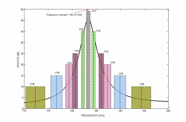
Figure 3 : The 6 channels of SAPHIR positioned versus the water vapour absorption line at 183,31 Ghz.
ScaRaB
ScaRaB (Scanner for Radiation Budget) is an optical scanning radiometer devoted to themeasurements of radiative fluxes at the top-of-atmosphere (TOA) in theshortwave and longwave domain.
The opticalradiometer is composed of 4 parallel and independent telescopes focusing thereflected solar and emitted thermal radiation of the earth atmosphere on 4detection channels with high absolute accuracy (1%-2%) owing to onboard calibration modules.